
“We departed from a set of locations (buildings, streets and zones), used by the drivers as navigational landmarks within certain neighborhoods. This time, we decided from the outset to limit our use of external geographical references, specifically when it came to defining the shapes and outlines of neighborhoods, relying instead on the locations mentioned by the drivers to derive the boundaries. Since we were dealing with an extensive dataset, it was essential to set rules – a human algorithm – that would ensure all interpretations and all iterations of a given operation would be consistent. The relation to the base map became central in this process: urban (infra)structures (malls, schools, universities, bridges, highways, river, …) proved that scale and embodied experience needed to be taken into account. This demonstrated early on the impossibility of relying on computation for generating these forms. Another challenge of this big dataset was its readability. More than ever, it was crucial for each map to be centered around one clear argument, which would determine everything from its scale and level of complexity, the degree of its legibility, its margin of error, title, legend, cropping, and visual treatment. In this sense, this dataset effectively produced a mapset, a series of cartographical snapshots that work together to deliver a glimpse into the complex lived geographies of Syrian deliverymen. Working across the levels of the city, of the neighborhood, and of the street allowed us to identify human-scale typologies of spatial understanding, to understand formations of neighborhoods, and to read city-scale geographies.”
“On the Mappability of Things” – Ahmad Gharbieh and Monica Basbous in Refugees as City-Makers, ed. Mona Fawaz, Ahmad Gharbieh, Mona Harb, Dounia Salamé, Beirut (AUB, IFI), 2018.
While working on the analysis and visualization of the data behind the editors’ contributions of Refugees as City-Makers, I repeatedly faced methodological and theoretical issues related to mapping and spatiality. However, due to some restriction in the scope of the publication, I kept notes and meta reflections on the sideline with the hope of returning to them later on. This post is a first step towards sharing some of these observations and tools, should they be of relevance or utility to others exploring similar terrains, or insightful for those curious about how these particular maps were produced.
In the excerpt above, Ahmad Gharbieh and I mention the need for setting rules (the “human algorithm”) to guide the making of the maps in the chapter “Seeing the city as a delivery-driver”. These rules were necessary because of the amount of data we were dealing with, and were a step towards ensuring that the first line we drew from this data would follow the same logic as the 1000th.
This post goes through the major 5 rules underlying the making of the mapset of “Seeing the city as a delivery-driver”.
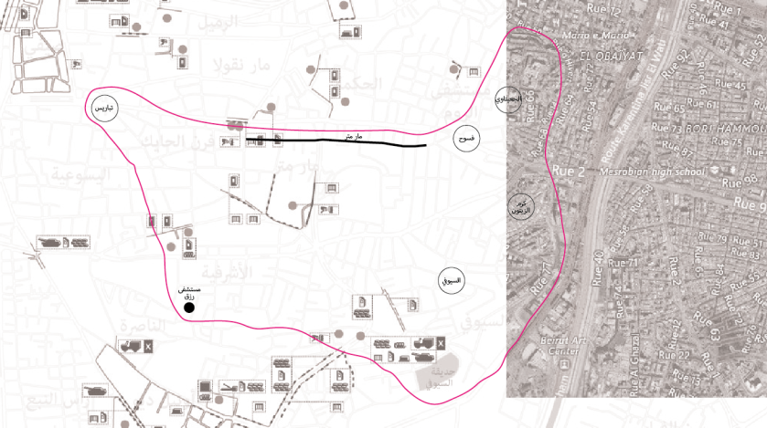
Below, the first map of the mapset plots each of the 1955 landmarks mentioned by interviewed drivers. This map includes three types of landmarks: (1) specific location points marked with a blue dot (e.g. checkpoints, stores, banks, hotels, universities), (2) streets, alleys, and highways market with a line, and (3) wider zones marked with a circle around the name (e.g. urban quarters, street markets, commercial districts). Because we found in this assemblage of tags, in the accuracy and confusions they make, an important entry point to understanding the everyday experiences of scooter drivers, we included any landmark they listed, whether it was an official name or a descriptive attribute (eg. tal3a, nazleh, or hajiz) and remained faithful in our visualizations to their answers, even when they made mistakes in naming the places, as in – most flagrantly – a response that confused AUB as LAU. In addition, we traced on the map a line around each cluster of landmarks identified by an individual driver as a “neighborhood”, accounting for the actual streets taken by the driver. Each cluster is colored with a translucent blue. Their overall ensemble, in turn, shows the spread of the drivers’ knowledge and its intensity with darker intensities of blue showing more frequent mention of a specific area. We shouldn’t however assume that the intensity of landmarks reflects a more intensive practice of a specific area. Rather, this mapping reflects the overlapping responses of the delivery drivers who shared their knowledge with us.

Rules for drawing the neighborhoods’ boundaries
Basic form
1. Points radiate over a distance that is correlated to their physical size and streets radiate over a distance that is correlated to the density of the fabric they are located in. These offsets are connected to form the individual boundary of a neighborhood.
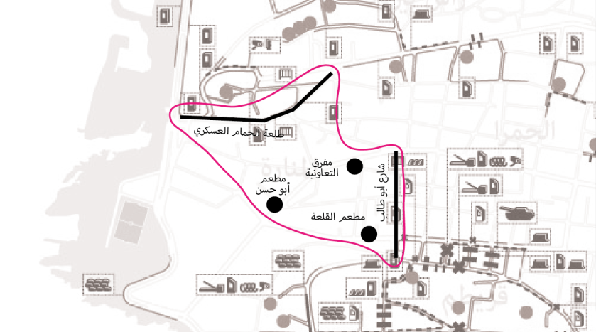
When scale matters
2. Points referring to large-scale sites allow the basemap to distort the boundary into the shape of the mentioned site.
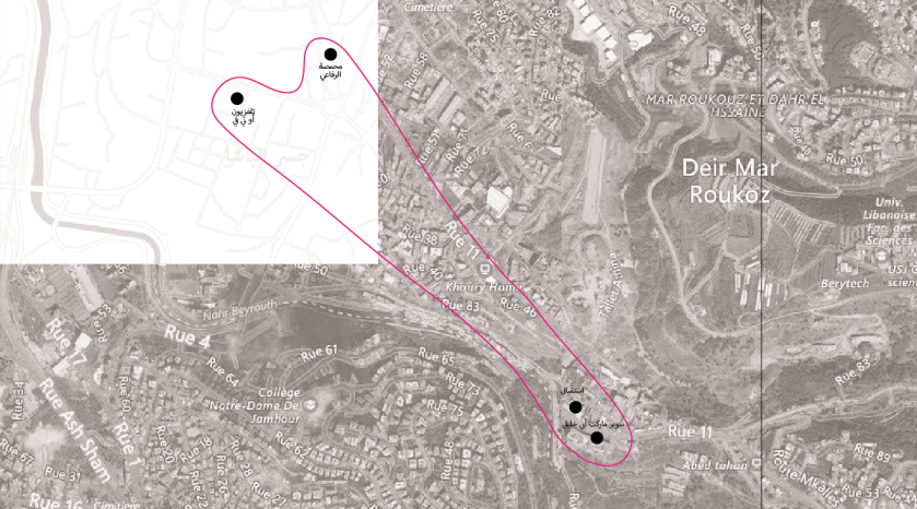
Abstracting urban morphology
3. If points are located within large distances (beyond pedestrian-scale), and not aligned along any major urban axis, they are connected by an abstracted, median line.
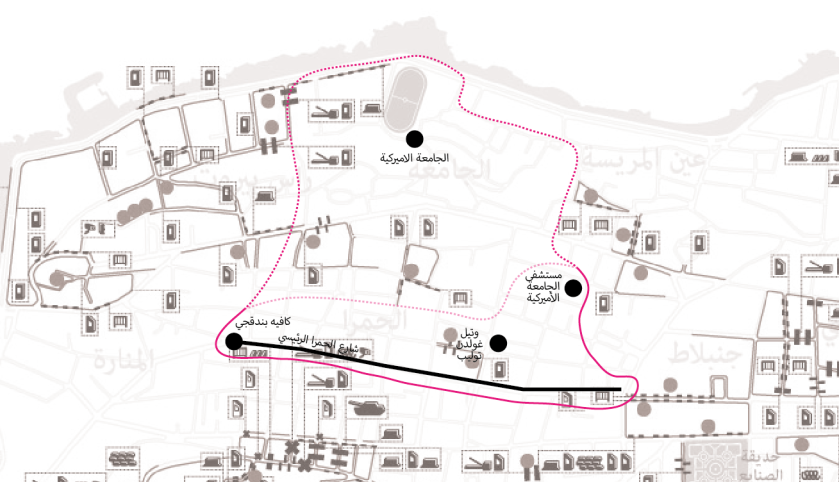
Accounting for urban morphology
4. When points fall along a basemap axis (main street, topographical edge, etc.), the boundary privileges this alignment over other possible connections with other points, even when it is not mentioned.
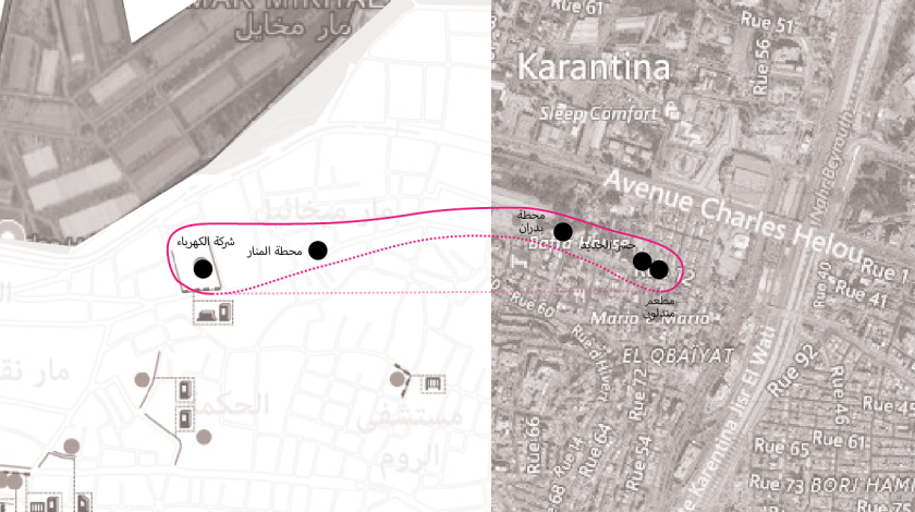
Streamlining unknowns
5. When neighborhoods are referred to as landmarks within the account of another neighborhood, the neighborhood boundary that includes them follows the outlines of the sector division map of Beirut (EDL, 1973)
Although simple, this set of rules introduced consistency into a process that relies substantially on the mappers’ interpretation and spatial knowledge, allowing to represent a complex geography of spatial practice and knowledge. The underlying rigor of this method also produced visualizations that could be read and compared and from which patterns can begin to emerge and observations be drawn.
We explore in other maps the differences in the accounts made by drivers. At the micro level, some patterns of spatial reasoning emerge from reading the map, showing that the city’s neighborhoods are typically understood along the configuration of specific landmarks. These intricacies, under-explored in the publication, will be developed in a later post.

Leave a comment